Navigation
USCG Light List and Waypoint Tools
Find all your waypoints with just a couple of mouse clicks
By Allen Edwards
UPDATE: I now download the light list data every week to keep it up to date. It is still not for navigation per NOAA so please double check anything you find here both by clicking on the map functions, and by verifying the locations. As they say, this is for entertainment only. Use official NOAA charts for navigation. Chart numbers will be listed in the application.
This project started out of my frustration in trying to enter a new race course into my GPS. It took hours to get the waypoints and routes in. With these tools, it can be done easily in minutes. The data is from the USCG Light Lists where all aids to navigation in the US and territories can be found and the ones of interest easily tranfered into the waypoint and routes bulk editor where a .gpx file can be created for download to your GPS. Waypoints can be found by simply clicking on a map defining your area of interest. This page is an overview of the tools.
But first: NOT FOR NAVIGATION. Note that what I am presenting is the use of a computer generated data base of aids to navigation. There are two reasons why these should not be used for navigation. The first are the many qualifications outlined by the Coast Guard in the publication. They can move, you might hit what they are marking, and they are not completely reliable. I was once in a race where the buoy marking the start-finish line moved about 200 yards during the race. The second reason is that this data base is computer generated and has not been verified. Basically, you will not know where a buoy is until you have been seen it and taken its position yourself. But this data base should certainly help you find it.
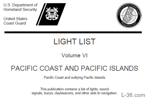
USCG Light List
USCG Light List
The USCG Light List is a series of 7 volumes that list the aids to navigation in the US and its territories. It is in pdf format and available
HERE. It is a great document but has a few problems in terms of finding the waypoints you want. What I have done is parse this and create a data base of the aids to navigation listed.
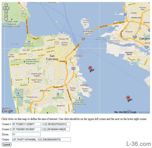
Map Interface
Light List Map Interface
There are two ways to access the waypoint data. One is by accessing the data base directly. I will discuss that later. The other is by using the map interface shown in the picture to the left. Using
http://l-36.com/light_list_map.php is simple. You zoom into your area of interest and mark the area with two mouse clicks which define opposite corners of a rectangle. If you make a mistake, just click again. The last two clicks define the rectangle. When you are satisfied, click the submit button at the bottom.
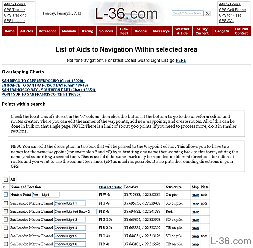
Filtered Aids from Light List
The map page submit button will take you to a page similar to the one shown on the left. This page lists the charts that overlap the area you have selected. These charts might contain potential waypoints. The list in the table below shows all the aids that are actually within your search rectangle.
Aids in Selected Area
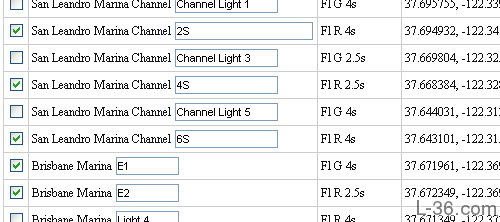
For my Beer Can Racing, we use fixed marks near our harbor, Brisbane Marina. These are the marks of interest.
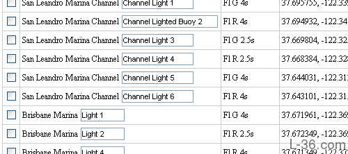
Select Waypoints
Here I have checked off the particular marks we race around, leaving the others blank. I could have selected all the marks on the list by checking the "all" box at the top of the form. In this case, I edited the waypoint names to match the race committee names. I also put the S on the names for the starboard roudings and if I was doing this for real, I would load these into the waypoint editor then come back to this page and create a 2P and 6P as one course goes the other way around the marks. For the sake of the explanation on the waypoint editor, I will assume I did not do any editing on this page.
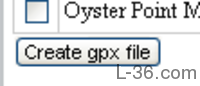
Submit Waypoints to Waypoint Editor
When all the waypoints are selected, hit the submit button (Create gpx file) at the bottom, which will take you to the waypoint editor where you can add your routes and download your gpx file. You can return to this page and add waypoints by clicking submit again. The waypoint editor will remember all your waypoints from past submissions. It will return any edits to their original names so it is best to either do your name edits on this page or wait until you have all your waypoints loaded to do your edits.
Waypoint Editor and Route Creator Tool
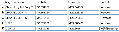
Waypoint Data Imported to Waypoint Editor
The waypoint data will now show up in the Waypoint Editor and Route Creator located at
http://l-36.com/waypoints.php. I am going to create some routes for my local Beer Can race in this example. The first step is to edit the waypoint names to match the names the club uses.
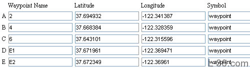
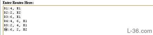
Edit the Waypoint Names
Here are the edited names. Pretty simple names I think.
Enter Route Information
To enter the routes, I am going to start by just copying and pasting the official routes from the sailing instructions.
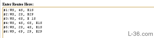
Edit Route Description
Here I have edited the route descriptions to match the way I have edited the Waypoints. I removed the first mark as it is not a fixed mark so we mark its location on the race course before the start. I also edited out the P and S. As two of our waypoints are left to either port or starboard depending on the course I had a choice of entering 2 for the blank waypoints and creating two spaces. I could then have copied the latitude and longitude information into these two new waypoints and created both a 6P and 6S waypoint. I could also have returned to the list of aids to navigation and loaded those two waypoints again. I chose to just edit out the P and S for this simple example.
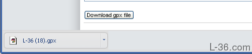
Download .gpx File
Click on the "Download .gpx File" submit button and your custom .gpx file will be in your download folder. If you make an error, you will be sent to an error page where the error will be displayed. You can then go back and correct the error. Errors are caused by a waypoint in the route not being named the same as the waypoint in the waypoint list. The final step is to download the data to your GPS. I use
EasyGPS for one of my GPS receivers, the other just looks like a folder on my computer and I just copy the .gpx file to that folder.
Source Data
NOTICE: Some pages have affiliate links to Amazon. As an Amazon Associate, I earn from qualifying purchases.
Please read website Cookie, Privacy, and Disclamers by clicking
HERE.
To contact me click
HERE. For my YouTube page click
HERE